The flood protection network was severely damaged leaving many residents without proper drainage and facing the risk of flooding during future rain events.
Council needs to urgently develop a plan to repair and rebuild the flood protection system to ensure the safety and well-being of its residents, as well as invest in new schemes to prevent further damage to public and private property.
The impacts of the cyclone across the flood protection system are from reduced capacity in the channels due to siltation, woody debris build up at structures and stopbanks that have either failed or are no longer fit for purpose.
The investment needed to restore damaged stopbanks and accelerate known flood bank projects, so the flood protection system is resilient and fit for purpose. Works continues as below:
Te Arai River - clearing log jams
Updated June 2023
Recovery work removing major log jams in the Te Arai River following Cyclone Gabrielle began but it has been put on hold now due to difficult access for machinery into the river, affecting safety and efficiency of works.
Central government have allocated a significant fund ($30 million +) toward removal of Large Woody Debris (LWD) and silt in Tairāwhiti. This enables a major regional project requiring significant planning to ensure success.
An Expression of Interest (EOI) process calling for contractor's interest in removing LWD has closed mid-June and is currently being assessed.
Site assessment and prioritisation is underway.
Realistically reasonable access to river sites will be gained in Spring or Summer to undertake removal of LWD.
What’s happening at Te Karaka?
Staff are analysing all the survey data of the middle reaches of the Waipaoa River, upstream of Kaitaratahi Bridge at Te Karaka.
This work involves identifying the reasons for flooding and making long term flood mitigation proposals for Te Karaka.
Flood spread mapping work is also in progress for modelling and then staff will come up with solutions for Te Karaka
Rural land drainage network
Updated June 2023
Work has started clearing silt from Council’s rural land drainage network.
Following Cyclone Gabrielle, the drains at Manutuke and Patutahi were fully flooded including some areas in Muriwai.
Contractors have started work at the Whatatuna Drain at Manutuke and from Opou Road early June. Work will also start in Patutahi from mid June.
One excavator can clear around 200m of drain each day, with some places needing more digging.
It’s estimated to take 25 days to clear 5km of drains, weather permitting.
Our plan is to clear 5km of drains in Patutahi, 4km in Manutuke and 2km in Muriwai initially at critical locations and then continue work in other areas.
We’re thankful for the recent fine weather to be able to start the work. The clearing work will be extended if the weather continues like this.
The high-water tables and soggy ground conditions has made it difficult for heavy machinery to get in and do the work until last week and we’re still experiencing difficulties at some sites.
Making the most of the fine weather, at the same time we’re weed spraying the drains as this was missed due to the wet summer and cyclones Hale and Gabrielle.
Usually, the drains are dug out and the silt is carted away. But due to the volume of silt, the huge workload and not enough work crews, we’ll dig the drain and leave the silt on the side as we need to use the resources and fine weather while we can.
We’re committed to clearing the rural drainage system before the winter and this is the quickest way to get the work done.
Roadside drains
Updated June 2023
Work on roadside drains and culverts continues. It’s estimated that there’s over 650,000m3 of silt to be removed from drains, slips and roads.
The silt needs to be carted to disposal sites once we gain landowner agreement and the sites are ready to take the material. Also, in some places the silt still needs to dry out before it can be removed.
We know where the worst affected areas are and we’re working as quickly as we can while also prioritizing reopening roads.
For more information on the initial $29M roading recovery work streams
Mangahauini River stopbank repair
Updated June 2023
Reconstruction of the Mangahauini River stopbank and erosion protection will help protect Tokomaru Bay township from flooding.
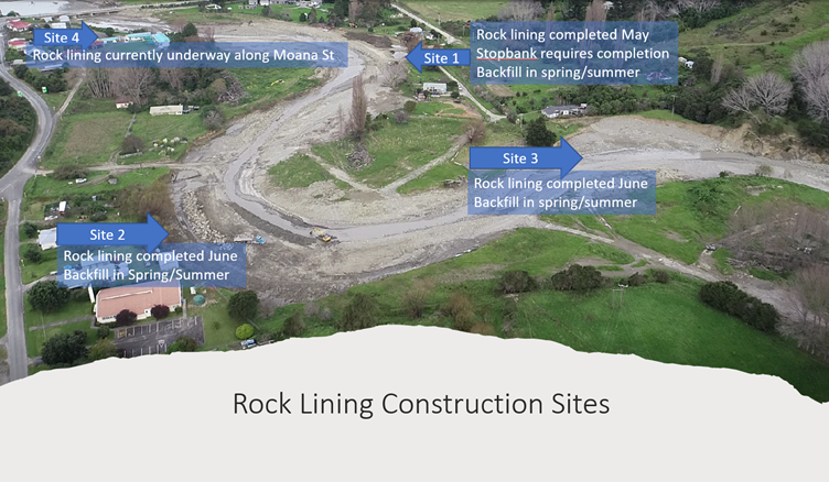
Site 1 - Required construction of a 230m section of rock armouring from the campground to 24 Mangahauini Street. This was completed in May 2023. The stopbank has been temporarily reinstated along this length awaiting drier conditions to fully complete.
Site 2 - 175m section of rock lining along Toa Street from Marotiri Street to the transfer station. This was completed in June 2023.
Site 3 - 135m section of rock lining at 19 Taro Street. This was completed in June 2023.
Site 4 - 195m section of rock lining from SH35 Bridge to the Kura. This is currently under construction. Expected completion mid-July.
Back filling of all the sites has been put on hold awaiting drier conditions.