The Gisborne / Tairāwhiti region is vulnerable to tsunami of any size at any time, so it's important to have a plan and know what to do. Use these maps to identify tsunami hazard areas, understand the red, orange and yellow evacuation zones and plan your safest route to higher ground.
If an earthquake is long or strong - get gone. Move immediately to high ground or as far inland as possible. Do not wait for an official warning.
Tsunami maps
View tsunami hazard and evacuation maps for coastal areas across Tairāwhiti. Be sure to read the information below explaining the red, orange and yellow tsunami zones before viewing or downloading a map.
The tsunami modelling is based on a major earthquake of approximately magnitude 8.9 centred in the Hikurangi Subduction Zone, located offshore from East Cape. The maps show areas that could be affected by tsunami inundation from an event of this size and help communities understand potential evacuation zones and associated risks.
Evacuation routes for Gisborne city
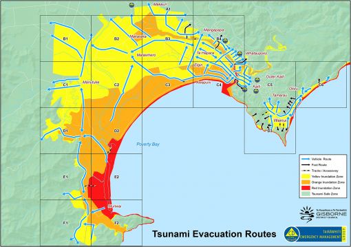
What the red, orange and yellow zones mean
Note: All zones must evacuate immediately in a Long or Strong earthquake.
Red zone = the highest risk zone. Evacuate from this zone in all types of tsunami warnings - natural or official, generated locally or distant.
This zone is likely to be inundated by a tsunami generated by a distant earthquake as far off as Chile. There may be many hours before the inundation hits and no natural warning.
Orange zone = evacuated in most, if not all, distant and regional-source official warnings.
This zone is likely to be inundated by a tsunami generated by an earthquake as close as the Kermadec Islands. It could take more than one hour for the inundation to hit and there may be no natural warning.
Yellow zone = local threat, you will feel a big earthquake and have up to 15 minutes to evacuate.
A big earthquake such as a magnitude 8.9 centred in the Hikurangi Subduction Zone, off East Cape, will be long and strong - so get gone. All zones must evacuate immediately.
Detailed evacuation routes by grid area
No results found for ""
Evacuation areas from Muriwai to East Cape
No results found for ""
Tsunami inundation modelling
Tsunami inundation based on an 8.9 magnitude earthquake in the Hikurangi subduction zone, off the East Coast.
Gisborne city
Wainui
Makorori
Tolaga Bay
Tokomaru Bay
Hicks Bay
Civil defence advice
Tairāwhiti Emergency Management
Website for latest situation updates
Civil defence
Advice and useful links
Rainfall
Hourly rainfall totals in mm
River cameras
Monitor river levels
Road closures
Local roads and state highways
Tsunami maps
Evacuation zones and inundation videos
Tsunami information
Earthquake and tsunami advice
Our Recovery
Following cyclones and storms in 2023
Plans and reports
Group plan, adverse event plan, flood plans, tsunami inundation report
CDEM Delegations
Appointments to roles or functions
CDEM Group
Statutory committee of Council meets quarterly
Hikurangi M9 workshop
Held in 2022 - speaker's videos