The Waipaoa Catchment Plan was developed alongside the Regional Freshwater Plan and publicly notified in 2015. The catchment plan needs to be reviewed to ensure it meets the National Policy Statement for Freshwater Management 2020 requirements.
This time a specific Waipaoa Catchment Advisory Group has been set up to guide the review of the catchment plan.
Timeline
Engagement with the Waipaoa Advisory Group is ongoing.
The review of the Waipaoa Catchment Plan will
- actively engage and collaborate with iwi and hapū in freshwater planning
- set up a freshwater advisory group to guide the review
- ensure residents and stakeholders have opportunities to inform how water will be managed
- provide clear direction for sustainable management of freshwater in the catchment.
Engagement with tangata whenua
Engagement with tangata whenua is central to the Waipaoa Catchment Plan and the freshwater planning process.
Through this engagement we hope to develop a vision for Te Mana o Te Wai and to work together to give effect to it. We also hope to recognise mana whenua values, matauranga and aspirations.
Community Engagement
We'll hold community workshops with residents and whānau from the catchment communities. All meetings are open to everyone.
Through community engagement we will:
- Reconfirm and identify any new issues and values of waterbodies in the catchment
- Reconfirm the freshwater management units (FMU)
- Review and confirm objectives
- Review targets, and change targets if appropriate
- Review water quality and quantity targets and change if appropriate
- Review and confirm non-regulatory projects that support achieving objectives and targets
The catchment plan should be ready for public notification by the end of 2026.
Waipaoa Advisory Group
The development of the Waipaoa Catchment Plan will be informed by the Advisory Group consisting of 20 members. Group members have committed to regularly attend monthly meetings to build an understanding of water quality and quantity issues in the catchment.
Members have strong link to the Waipaoa Catchment and represent a range of community perspectives. The advisory group 1. members are:
- Alan Haronga
- David Hawea
- Grant Vincent
- Jacob Harrison
- Matawhero Lloyd
- Murray Palmer
- Nick Briant
- Owen Lloyd
- Phil Gaukrodger
- Samuel Lewis
- Shanna Cairns
- Stan Pardoe
- Stuart Davis
- Tim Rhodes
- Timothy Tietjen
- Leo Kelso
- Joss Ruifrok
- Bella Hawkins
- Hannah Kohn
- Tash Irwin
- Hui 1 Agenda - 12 July 2023
- Hui 2 Agenda - 16 August 2023
- Hui 3 Agenda - 13 September 2023
- Hui 4 Agenda - 11 October 2023
- Combined Hui 4.5 Agenda - 15 November 2023
- Hui 5 Agenda - 13 December 2023
- Hui 6 Agenda - 13 March 2024
- Hui 7 Agenda - 24 April 2024
- Hui 8 Agenda - 29 May 2024
- Hui 9 Agenda - 10 July 2024
- Hui 10 Agenda - 21 August 2024
- Combined Hui 11 Agenda - 9 October 2024
- Combined Hui 12 Agenda - 20 November 2024
- Hui 1 Minutes - 12 July 2023
- Hui 2 Minutes - 16 August 2023
- Hui 3 Minutes - 13 September 2023
- Hui 4 Minutes - 11 October 2023
- Hui 4.5 Minutes - 15 November 2023
- Hui 5 Minutes - 13 December 2023
- Hui 6 Minutes - 13 March 2024
- Hui 7 Minutes - 24 April 2024
- Hui 8 Minutes - 29 May 2024
- Hui 9 Minutes - 10 July 2024
- Hui 10 Minutes - 21 August 2024
- Hui 11 Minutes - 9 October 2024
- Hui 12 Minutes - 20 November 2024
- Hui 1 Report 1 - Overview - 12 July 2023
- Hui 1 Report 2 - TMOTW - 12 July 2023
- Hui 2 Report - Values Introduction - 16 August 2023
- Hui 3 Report 1 - Identify Values - 13 September 2023
- Hui 3 Report 2 - Freshwater Management Units - 13 September 2023
- Hui 4 Report 1 - Values and draft environmental outcomes - 11 October 2023
- Hui 4 Report 2 - Water quality in the Waipaoa Catchment - 11 October 2023
- Hui 4.5 Combined Report 1 - 15 November 2023
- Hui 4.5 Combined Report 2 - 15 November 2023
- Hui 5 Report 1 - Environmental Outcomes -13 December 2023
- Hui 5 Report 2 - Outstanding Waterbodies - 13 December 2023
- Hui 6 Report 1 - Target attribute states - 13 March 2024
- Hui 7 Report 1 - Water quantity issues - 24 April 2024
- Hui 8 Report 1 - Water Quantity – Minimum Flows and Allocation Blocks - 29 May 2024
- Hui 9 Report 1 - Water Quantity – Minimum Flows and Allocation Blocks – Scenarios for Analysis - 10 July 2024
- Hui 10 Report 1 - Development of the Action Plan - 21 August 2024
- Hui 11 Combined Report 1 - Water Quantity Management - Direction for Policy Development - 9 October 2024
- Hui 11 Combined Report 2 - Water Quantity Management - Municipal and Community Supply - 9 October 2024
- Hui 11 Combined Report 3 - Water Quantity in the Waipaoa Catchment, Summary and Update - 9 October 2024
- Hui 12 Combined Report 1 - Outstanding Water Bodies - 20 November 2024
- Hui 12 Combined Report 2 - Water Security Programme - 20 November 2024
- Hui 12 Combined Report 3 - Wetlands Identification - 20 November 2024
- Hui 12 Combined Report 4 - Evidence Base - 20 November 2024
- Hui 12 Combined Report 5 - Transition Advisory Group - 20 November 2024
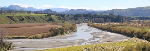
About the Waipaoa Catchment
The Waipaoa River catchment is extensively farmed. It covers 216,484 ha and has formed the fertile and highly productive Poverty Bay flats on the edge of Gisborne city. It is an important source of water for irrigation, a back-up source of water for Gisborne city, and the major recharge source for extensively used aquifers.
Key subcatchments of the Waipaoa include the Waikohu, Mangatu, Waingaromia, Wharekopae, and Te Arai.
Some areas are particularly susceptible to soil erosion, notably in the Waingaromia and Mangatu subcatchments. As a result, the bed in the lower reaches of the catchment is building up due to sediment and gravel deposition. The Poverty Bay Flats and the city are protected by the stopbanks of the Waipaoa River Flood Control Scheme. Annual suspended sediment load for the Waipaoa catchment is 15 million tonnes or 33.54 cubic metres per second. This amount of sediment enters Poverty Bay.
Despite the high sediment loads of the lower reaches of the Waipaoa catchment many of the tributaries in the headwaters provide habitat for a range of indigenous fish species. These species rely on migration up the river system as juveniles and return to the sea as adults. Eels are one example in the fishery that requires this ability to migrate.
Trout are present in the Wharekopae tributary. They have been introduced and are not known to migrate.
Waipaoa Catchment Map

How to get involved
- Participate in our open engagement projects - Kōrero mai - Have your say
- Ask us a question - email the team at trmp at gdc.govt.nz
- Sign up for Council News | He Pānui - using this form.