We are developing the Waiapu Catchment Plan with Te Runanganui o Ngati Porou (TRONPnui) as part of implementing the National Policy Statement for Freshwater Management. The joint development of the plan is enabled through the Joint Management Agreement
The plan will also have input from the wider community and Ngati Porou whānau and hapū.
The Waiapu Catchment Plan will provide a long-term vision for how freshwater and other natural resources are managed. It will incorporate Matauranga Ngāti Porou and western science to support integrated management of freshwater and other resources from the mountains to the sea.
How the Plan Stop legislation affects our timeline
Councils cannot notify new plan changes or reviews from 21 August 2025 to 31 December 2027 unless they have been granted an exemption. This pause means the timeline and scope of the catchment plans may need to change, as required under the Government's Plan Stop legislation
Waiapu catchment technical advisory group
Council and Te Runanganui o Ngati Porou have established an advisory group made up of people with technical and practical expertise in freshwater management, along with strong connection to the Waiapu catchment area. The group represent a range of community perspectives.
- Hui 1 - Report 1 - Scope of Waiapu Catchment Plan
- Hui 1 - Report 2 - Long Term Vision
- Hui 1 - Report 3 - Values
- Hui 2 - Report 1 - Values and Environmental Outcomes
- Hui 2 - Report 2 - Management Zones
- Hui 2 - Report 3 - State of Environment, Baseline and Target Attribute States
- Hui 2 - Report 4 - Outstanding Waterbodies
- Hui 3 - Report 1 - Gravel Management in Ngā Wai o Waiapu
- Hui 3 - Report 2 - Managing Water Quantity in Nga Wai o Waiapu
- Hui 4 - Report 1 - Action Planning
- Hui 4 - Report 2 - Monitoring and Site Attributes
- Hui 4 - Report 3 - Scheduled Waterbody implications
About the Waiapu Catchment Plan
The catchment plan will:
- give effect to Te Mana o te Wai and the Ngati Porou Joint Management Agreement
- ensure the mauri and values of waterways are recognised, protected and enhanced
- align with Ngati Porou and community values and aspirations
- ensure residents and stakeholders have opportunities to inform how water will be managed
- provide clear direction for sustainable management of freshwater in the catchment.
Te Mana o Te Wai is the concept that defines how all freshwater management decisions are made.
It refers to the fundamental importance of water and recognises that protecting the health of freshwater protects the health and well-being of the wider environment. It protects the mauri of the wai. Te Mana o Te Wai is about restoring and preserving the balance between the water, the wider environment, and the community by defining the following hierarchy that will be applied to all freshwater management decisions.
- The health and wellbeing of water bodies and freshwater ecosystems
- The health and needs of the people (such as drinking water)
- People and communities to provide for their social, economic and cultural wellbeing, now and into the future.
Community engagement
Through community engagement, we will discuss:
- issues and values of waterbodies in the catchment
- freshwater management units (FMU)
- catchment objectives
- environmental outcomes and targets
- actions that support catchment objectives and targets.
Tangata whenua
We are working in partnership with TRONPnui to engage with Ngāti Porou whānau, hapū, marae and landowners.
Stakeholder engagement
Working with stakeholders is essential in the development of the plan. We've developed a questionnaire to help us understand thoughts on freshwater issues. Workshops will be held as the plan progresses and we gain further understanding of sector interests.
The purpose of this group is to enable technical expertise, applied with a local lens, to support the development of the Waiapu Catchment Plan.
The Group will meet every 1-2 months, starting April 2025. Meetings will be 3 hrs long.
Seven meetings are planned and will be held in the Waiapu catchment area at a venue to be confirmed. It is important that members are able and willing to commit to the process for its full duration.
As such, members:
- are expected to work collaboratively and respect other viewpoints.
- should live within the catchment area or demonstrate a strong association with the catchment area.
- are expected to attend all of the meetings.
- will receive pre-reading material ahead of meetings and are expected to come prepared to the meetings.
- should also be able to act as a conduit of information to the wider community.
Evaluation of applications
Council and TRONPnui will evaluate applications to determine the suitability of applicants, and to ensure an appropriate size and composition of membership and representation of skills.
Criteria for evaluating applications are:
- Demonstrated link to the Waiapu Catchment area.
- Have an active interest in freshwater and applicable experience.
- Demonstrated ability to work with others and collaborate.
- Ability to support engagement with hapu, community and stakeholders.
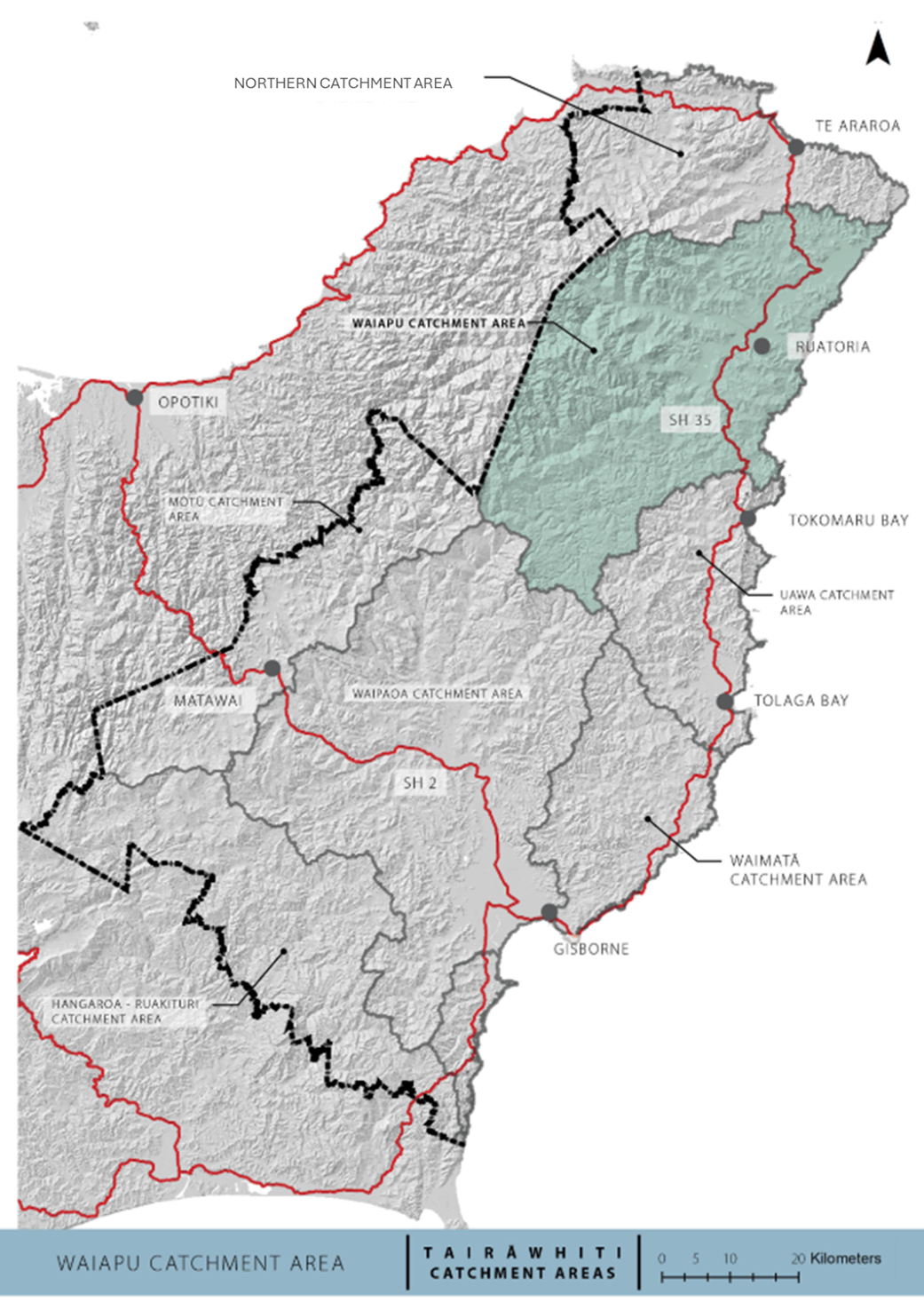
About the Waiapu Catchment
The Waiapu Catchment has an area of 1734 km2 making it the largest river catchment in the Ngati Porou rohe and the second largest in the Tairāwhiti region.
Originating in the Raukumara Ranges, the Waiapu River begins at the confluence of the Mata and Tapuaeroa Rivers, just above the Rotokautuku Bridge at Ruatorea.
The river spans 26 kilometres through a system of river flats and flows to the coast at the ngutu awa (river mouth).
The Mata River is the largest tributary of the Waiapu and therefore the majority of the Waiapu Catchment is upstream of the Waiapu River in the Mata sub-catchment.
The Mata River catchment also consists of the following tributaries:
- Waitahaia River
- Waingakia Stream
- Ihungia River
- Makarika Stream
- Aorangiwai Stream
- Makatote Stream
Other tributaries that flow directly into the Waiapu River include:
- Mangaoporo River
- Poroporo River
- Maraehara River
The coastal catchments adjacent to the Waiapu Catchment will also be included in the Waiapu Catchment Plan. This includes streams flowing directly to the sea from Whangaokena to Koutunui Head to align with the management arrangements in Nga Rohe Moana o Nga Hapu o Ngati Porou Act 2019.
Current state of the wai
- Most water use in the catchment is for drinking water, swimming and stock water.
- There are 2 consents to take water within the catchment and 2 expired consents to take geothermal water at Te Puia Springs.
- There are many puna/springs, and many whanau source their domestic water from springs and awa as permitted takes.
- There is a large amount of gravel extracted from a range of rivers in the catchment, but particularly from the Mata, Waiapu
and Tapuaeroa Rivers. - As of February 2020, rates of consented gravel extraction from the catchment are in the order of 450,000m3/year, with 150,000m3/year from the mainstem Waiapu River. This is considerably more than the amount of net bedload transfer for the mainstem which is assessed as being around 35,000 – 45,000m3/year.
- Water quality across the catchment is impacted mainly by sediment and E.coli (bacteria).
- Water quality and stream health is generally good in the headwaters but deteriorates once the rivers flow through the
catchment. - Many of the monitoring sites are below national bottom lines for visual clarity (sediment), E.coli (bacteria), deposited sediment (on the river bed) and ecosystem health (macroinvertebrates).
Key Environmental Issues
- Managing gravel extraction within sustainable limits.
- Ongoing erosion and instability generating large amounts of sediment.
- Stock access to rivers causing high levels of E.coli.
- Poor ecosystem health in many rivers and streams
How to get involved
- Check for any open engagements - kōrero mai via our engagement portal
- Ask us a question - email the team at service@gdc.govt.nz
- Sign up for Council News | He Pānui - using this form.