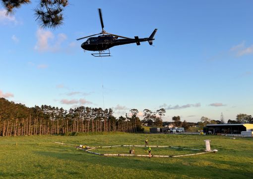
To understand more about our region's groundwater, we carried carried out aerial mapping in January 2024. The technology scanned down about 300m deep underground.
The goal is to improve our understanding of the Poverty Bay Flats and coastal sands aquifer systems. To better understand groundwater resources in the Te Araroa, Hicks Bay and Ruatoria areas and better understand surface water flows in Maraehara, Waiomoko and Pakarae rivers.

What the information will be used for
The information gathered by the helicopter and loop will take some time to process and analyse.
Once available, it will provide a much better picture of the underground resource and reduce uncertainty to help guide decisions for environmental protection, development, resource consents, water management, and water availability for the local community.
The project has formed from collaboration between AIA and Gisborne District Council, in discussion with iwi.
The $1.8 million project is largely funded through Aqua Intel Aotearoa, a national programme on regional water availability and storage.
AIA is a collaboration between Kānoa (the delivery arm of the Provincial Growth Fund) and GNS Science.
The project is being undertaken by Aqua Intel Aotearoa (a partnership between GNS Science and Kanoa, funded by the Provincial Growth Fund) and Gisborne District Council.
The project has been planned in discussion with Te Runanganui o Ngāti Porou, Tāmanuhiri Tūtū Poroporo Trust, Te Aitanga a Māhaki Trust, and Rongowhakaata Iwi Trust.
All 4 iwi have indicated they support the objective of gathering scientific information to guide decision making.
Iwi are involved in finalising data management and governance arrangements for accessing, storing and using the data for future purposes.
The SkyTEM data collection is being carried out by the international company SkyTEM in collaboration with the New Zealand helicopter company Heli A1.
The project is being undertaken by Aqua Intel Aotearoa, a partnership between GNS Science and Kanoa, funded by the Provincial Growth Fund.
Gisborne District Council is contributing funding to the project which has been considered and scoped alongside Tairāwhiti iwi representatives.
The SkyTEM data collection is being carried out by the international company SkyTEM in collaboration with the New Zealand helicopter company Heli A1.
For more information
Visit AquaIntel website
