Gisborne District Council is developing a Waimatā-Pakarae Catchment Plan as part of its implementation of the National Policy Statement for Freshwater Management.
Aim of the Waimatā - Pakarae Catchment Plan
- Ensure the mauri and values of waterways are recognised, protected and enhanced.
- Ensure the interests and rights of tangata whenua are reflected in the plan.
- Ensure residents and stakeholders have opportunities to inform how water will be managed.
- Provide clear direction for sustainable management of freshwater in the catchment.
- Help meet Council’s obligations under the National Policy Statement for Freshwater Management.
Engagement with tangata whenua
Tikanga, matauranga, kaitakitanga and the aspirations of mana whenua are essential for designing the values, objectives, limits and activities in the catchment plan.
Initial contact has been made and we will work with tangata whenua to get their input into the catchment plan process.
Community and wider engagement
We'll hold community workshops with stakeholder groups, residents and whānau from the catchment communities. All these meetings are open to everyone.
Plan Stop legislation may affect the timeline
The government’s Plan Stop legislation came into effect on 21 August 2025. This means that until 31 December 2027, councils can’t notify new plan changes or reviews unless they have an exemption.
This may affect the timeline and scope of the catchment plans.
Waimatā - Pakarae Advisory Group
Engagement with the Waimatā-Pakarae Advisory Group is complete.
The development of the Waimatā-Pakarae Catchment Plan will be informed by the Advisory Group consisting of 9 members. Group members have committed to regularly attend monthly meetings to build an understanding of water quality and quantity issues in the catchment.
Members have strong link to Tairāwhiti region and/or the Waimatā-Pakarae Catchment, interest in freshwater, and represent a range of community perspectives. The advisory group members are:
- Laura Watson
- Sarah Williams
- Maraea Hinemoa Aupouri
- Stephanie Gardner
- Stan Pardoe
- Colin Kerslake
- Jennie Hindmarsh
- Tania Swift
- Tash Irwin
- Hui 1 Report 1 - Freshwater Management Unit Option Analysis - 27 February 2024
- Hui 2 Report 2 - Vision, Values, FMUs and Outcomes - 10 April 2024
- Hui 3 Report 1 - Values, Environmental Outcomes, FMU Options - 21 May 2024
- Hui 4 Report 1- FMU Analysis - 2 July 2024
- Hui 5 Briefing paper 1 - Environmental outcomes and BAS v2 - 13 August 2024
- Hui 6 Report - Moving From High Level into the Detail - 24 September 2024
- Hui 7 Report 1 - Flow Setting - 5 November 2024
- Hui 7 Report 2 - Scheduled Waterbodies - 5 November 2024
- Hui 7 Report 3 - Baseline States - 5 November 2024
- Hui 8 Report - Attributes and Actions - 10 December 2024
About the Waimatā-Pakarae catchment
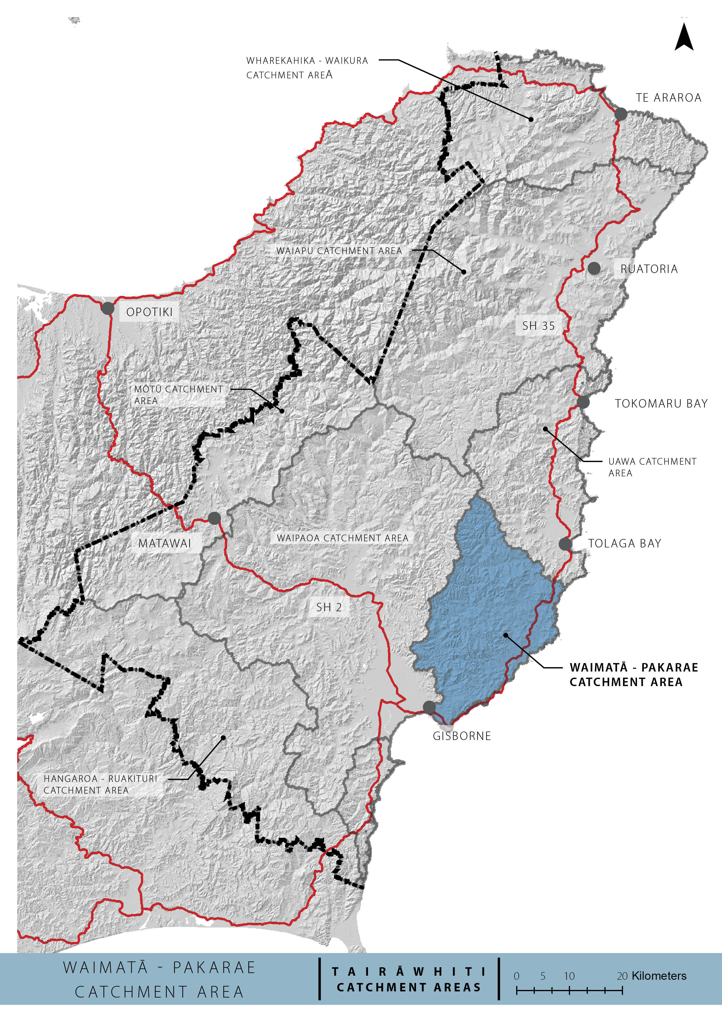
The Waimatā-Pakarae Catchment Plan area represents 8 freshwater catchments that flow to the eastern coastline from Gisborne city at its southern extent to Waihau Bay just south of Tolaga Bay.
These catchments include:
- the Waimatā River which is located directly north of Gisborne city,
- the Pakarae River which is located south of Tolaga Bay,
- several smaller catchments located along the coastal margin between the Pakarae River and Gisborne City. These catchments include the Waiomoko River, Pouawa River, Turihaua Stream, Hamanatua Stream, Wainui Stream and Kopuawhakapata Stream.
The Waimatā River is one of Gisborne city's 3 rivers that flow through the inner city area. Land use is mainly typical Gisborne hill country sheep and cattle farming with large areas of exotic forest on the steeper inland areas.
Their combined total area is 650km2. The 2 largest are Pakarae (243km2) and the Waimatā (227km2) catchments.
Land use across much of the wider Waimatā – Pakarae Catchment area is rural, predominantly sheep and beef farming and some areas of exotic forest in the upper Waimatā and Pakarae Catchment. In contrast, the downstream reach of the Waimatā River and the Kopuawhakapata and Wainui streams run through the Gisborne urban area.
Council has a number of water quality and bio-monitoring sites in the catchment area, which provide a snapshot of the current state of the rivers. In summary:
- Nitrate and Dissolved Inorganic Nitrogen are very low or low (good);
- Sediment and turbidity are generally high (poor) and do not currently meet minimum levels set in the National Policy Statement for Freshwater Management (national bottom lines);
- All sites have elevated levels of bacteria (E.coli) and do not meet national bottom lines;
- Ecosystem health is variable across the catchment area, with the monitoring sites showing moderate to significant degradation.
In addition, the Wainui and Kopuawhakapata urban streams have evidence of chronic pollution including low dissolved oxygen and elevated bacteria levels. Microbiological source tracking in some streams indicates that the E.coli are derived from a range of sources including ruminant (cattle/sheep), avian (birds/fowl), dog and human.
Further information can be found in the Waimatā-Pakarae Catchment background report.
Catchment map

How to get involved
- Check for our open engagements - kōrero mai via our engagement portal
- Ask us a question - email the team at trmp@gdc.govt.nz
- Sign up for Council News | He Pānui - using this form.
