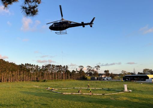
Whakamahere-mai-rangi i o tātau Wai Rarowhenua

Aerial mapping of aquifers

An aerial mapping project to understand more about our region's groundwater is to start in January 2024. It was delayed due to Cyclone Gabrielle. For more information see AquaIntel's website

You may see a low-flying helicopter towing a large loop hanging from a cable. The technology will scan down about 300m deep underground.

The helicopter will be mapping aquifers in Hicks Bay, Te Araroa, Waiapu, Tolaga Bay and across the Poverty Bay Flats.

They won't fly over towns or built-up areas. We want to assure you that these flights are not in any way used for compliance monitoring. We only want to know about water – not what you’re doing on your property.

The goal is to improve our understanding of the Poverty Bay Flats and coastal sands aquifer systems. To better understand groundwater resources in the Te Araroa, Hicks Bay and Ruatoria areas and better understand surface water flows in Maraehara, Waiomoko and Pakarae rivers.

This animation explains the project

About the flight and safety

The helicopter will fly at 80-120km/hr in parallel lines generally 200m apart and at a height of approximately 100m.

The measurement instruments are suspended under the helicopter and will be about 30-50m above the ground.

The noise from the helicopter has been described as equivalent to a truck going past on a motorway and lasts for around 2 to 4 minutes.

The helicopter flies up and down in lines, so once it flies over, it will then return approximately 15 minutes later but be at least 200m further away.

We will not be gathering data or information on anything above ground. While the helicopter will carry a camera, this is only to guide the crew managing the slung load, and no photos or video are retained or shared.

Transmitters on the loop under the helicopter send electromagnetic signals underground, and sensors measure the behaviour of the returning signals. Think of it as similar to radar, sending out and receiving signals.

The technology has been used commercially since 2004 to map large aquifer systems in countries including Denmark, Netherlands, India, USA, Canada, Australia and New Zealand.

Yes, very safe.

Because the helicopter is moving at high speed, there’s very limited exposure to the electromagnetic signals. It’s safer than watching a LCD or plasma TV or blow-drying your hair!

What about my animals?

The technology is safe to use above animals.

Experience in other farming areas is that stock generally aren’t disturbed much by the technology. In New Zealand the team has observed that horses moved to the other side of the paddock when the system came very near.

Helicopter

What the information will be used for

The information gathered by the helicopter and loop will take some time to process and analyse.

Once available, it will provide a much better picture of the underground resource and reduce uncertainty to help guide decisions for environmental protection, development, resource consents, water management, and water availability for the local community.

The project has formed from collaboration between AIA and Gisborne District Council, in discussion with iwi.

The $1.8 million project is largely funded through Aqua Intel Aotearoa, a national programme on regional water availability and storage.

AIA is a collaboration between Kānoa (the delivery arm of the Provincial Growth Fund) and GNS Science.

The project is being undertaken by Aqua Intel Aotearoa (a partnership between GNS Science and Kanoa, funded by the Provincial Growth Fund) and Gisborne District Council.

The project has been planned in discussion with Te Runanganui o Ngāti Porou, Tāmanuhiri Tūtū Poroporo Trust, Te Aitanga a Māhaki Trust, and Rongowhakaata Iwi Trust.

All 4 iwi have indicated they support the objective of gathering scientific information to guide decision making.

Iwi are involved in finalising data management and governance arrangements for accessing, storing and using the data for future purposes.

The SkyTEM data collection is being carried out by the international company SkyTEM in collaboration with the New Zealand helicopter company Heli A1.

The project is being undertaken by Aqua Intel Aotearoa, a partnership between GNS Science and Kanoa, funded by the Provincial Growth Fund.

Gisborne District Council is contributing funding to the project which has been considered and scoped alongside Tairāwhiti iwi representatives.

The SkyTEM data collection is being carried out by the international company SkyTEM in collaboration with the New Zealand helicopter company Heli A1.

Get in touch

Please contact us if you have any questions or concerns about helicopter flights over your place.

Let us know if you have an event you’d like us to avoid such as a stock sale, wedding, hui and we’ll do our best to plan around it.

Contact our customer service team or email Aqua Intel Aotearoa [email protected]

For more information

AquaIntel website