Council is preparing to develop a Northern Catchment Plan as part of its implementation of the National Policy Statement for Freshwater Management.
The Northern Catchment Plan will include the Wharekahika, Waikura, Karakatuwhero, Awatere, Orutua and Waipapa catchments within Tairāwhiti. The plan will set the regulatory and non-regulatory framework for water quality and quantity within the catchment and eventually sit within the Tairāwhiti Resource Management Plan.
Development of the Northern Catchment Plan
- Ensure the mauri and values of waterways are recognised.
- Ensure the interests and rights of tangata whenua are reflected in the plan.
- Ensure residents and stakeholders have opportunities to inform how water will be managed.
- Provide clear direction for sustainable management of freshwater in the catchment.
Engagement with tangata whenua
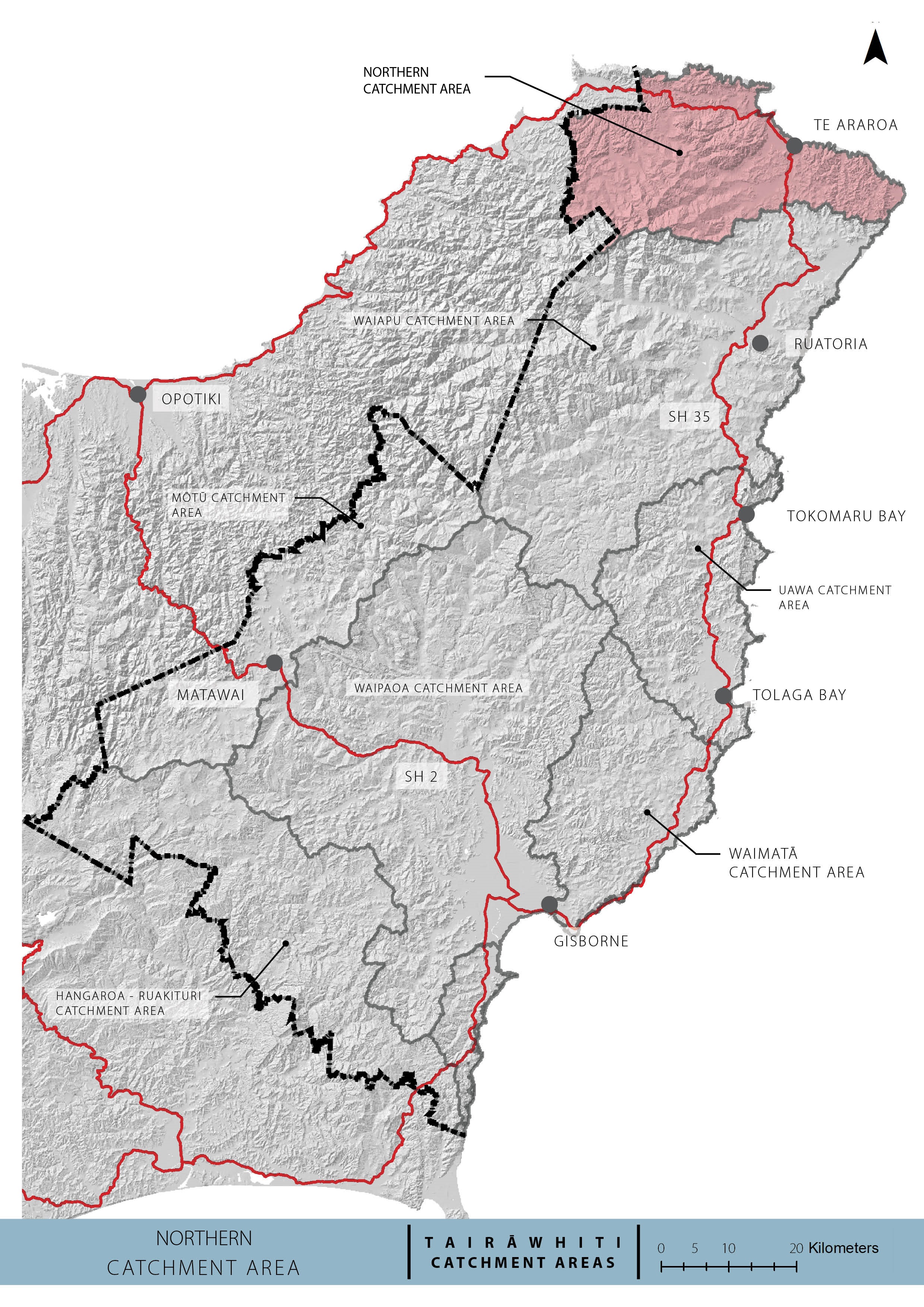
The Northern catchment area lies within the rohe of Ngāti Porou iwi, with the Raukokere and Whangaparaoa River catchments also extending into the rohe of Te Whānau ā Apanui and the Bay of Plenty region.
We have informed iwi about the proposed engagement approach for the Northern Catchment Plan and invite input on how they would like to be involved in the process.
Plan Stop legislation may affect the timeline
The government’s Plan Stop legislation came into effect on 21 August 2025. This means that until 31 December 2027, councils can’t notify new plan changes or reviews unless they have an exemption.
This may affect the timeline and scope of the catchment plans.
Northern Catchment Local Panel
We have formed a local panel of highly engaged community members with a strong interest in freshwater catchment planning. The panel will play an important role in helping inform the development of the catchment plan and keeping communities informed about the planning process.
Council and panel members will also facilitate public hui in 2025 to broaden community engagement.
This plan will guide freshwater management by forming a values-based vision, with actions to achieve this vision, for all the waterways in the catchments. It will set objectives and regulations to help us manage water quality and quantity.
- Latasha Wanoa – Local technical expert
- Hal Hovell – Local technical expert
- Trudy Ngawhare – Technical support and communications
- Joe Baulkham – Technical expert, farming and Land Trustee
About the Northern Catchment
The Northern Catchment covers approximately 669km2 in area. The townships in this catchment are Pōtaka, Wharekahika (Hicks Bay), and Te Araroa. The catchment includes:
- Waikura catchment
- Whangaparaoa catchment
- Wharekahika catchment
- Karakatuwhero catchment
- Awatere catchment
- Orutua catchment
- Waipapa catchment
- Several small catchments along the coastal margin
The Wharekahika catchment is the northern most catchment in the Gisborne District, with its headwaters bounding the Bay of Plenty region. It discharges into Hicks Bay from a catchment area of 148 km2.
Land cover in the Wharekahika catchment is mainly indigenous scrub and forest with some extensive farming near the mouth and limited areas of exotic pine forest.
Native fish species that inhabit the Wharekahika are a key value, and water quality is generally maintained due to the lack of erosion-prone soils in the catchment and the minimal modification from intensive land use. The native fish in Wharekahika have been ranked as nationally significant by the River Values Assessment Project (RIVAS).
The Wharekahika has a permanent monitoring site near the Wharf Road bridge approximately 1km inland from the river mouth. Data has been collected from this site six times per year, with records available since 1995.
The Awatere river catchment covers 172 km² and includes the Kopuapounamu and Tauraungakautuka rivers as tributaries. More than half of the catchment is covered in either indigenous or exotic forest.
Several operators extract shingle for roading from the Awatere and its tributaries.
Native fish species in the Awatere catchment are found in good numbers and have been assessed as nationally significant by the River Values Assessment project (RIVAS).
Water quality in the Awatere has been monitored since 2003, with some less reliable information available from 1973 to 1983.
Karakatuwhero river flows from the northern tip of the Raukumara ranges into the bay at Te Araroa East Cape. The catchment is relatively small, covering an area of 78 km². Its tributaries run through ancient basalt rock formations, which are steep and supply hard boulders that fall into the river, creating habitat for a diverse range of native fish. Populations of Hochstetter’s frog are also found within the catchment
Good quality shingle is extracted from the Karakatuwhero, providing a valuable resource for East Cape roads. Land cover is predominantly indigenous.
Map of the Northern Catchment

How to get involved
We'll be asking for expressions of interest in the advisory group later this year, but in the meantime you can:
- Check for any open engagements - kōrero mai via our engagement portal
- Ask us a question - email the team at trmp@gdc.govt.nz
- Sign up for Council News | He Pānui - using this form.
