Alcohol is banned in some areas of our district at certain times.
An alcohol ban means it's an offence to drink, carry or bring opened alcohol in those public places. This means you can only drink alcohol in a building, licensed premises or on your own property.
Police enforce alcohol bans and will issue a fine for a breach of an alcohol ban. The maximum fine is $250.
City area alcohol bans
Our city centre is a permanent alcohol free zone at all times.
The area bounded by and inclusive of :
- Roebuck Road
- Taruheru River (southern bank)
- Turanganui River (western bank) and
- Waikanae Creek (northern bank) as detailed on the map below:
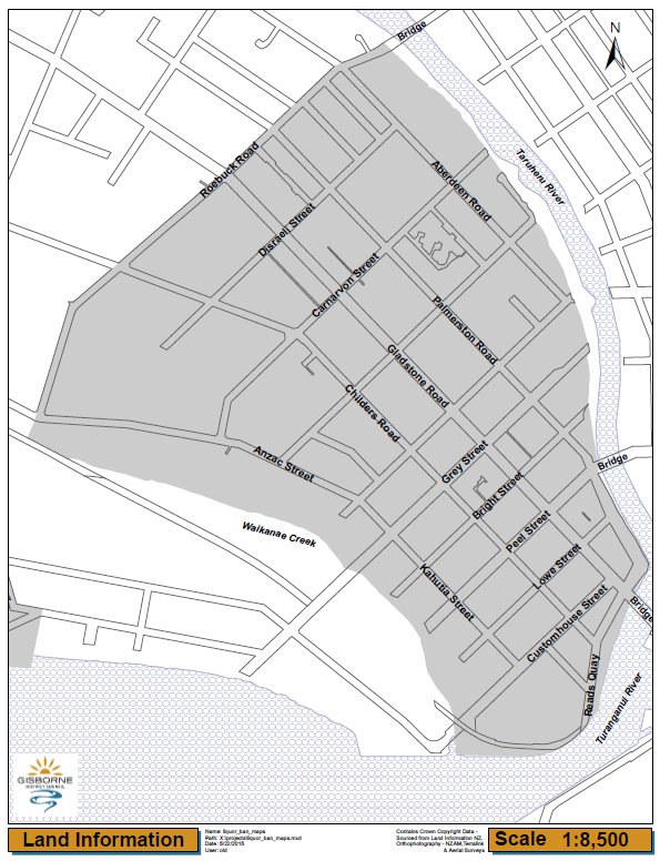
Midway - Gisborne city
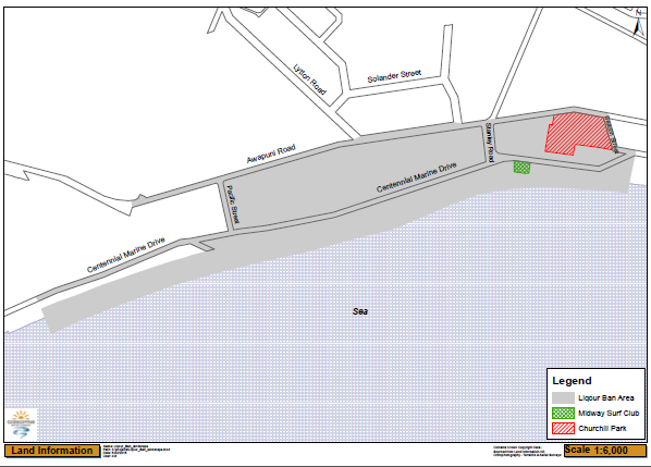
From 8am 27 December to 6pm 1 January on any year
Area bounded by and inclusive of:
- Awapuni Road - from Beacon Street to Pacific Street
- Centennial Marine Drive - inclusive of beach front from Salisbury Road to the beacon.
Together with all council reserves and land contained and detailed in the map below but excluding the areas identified as excluded on the map.
City - temporary alcohol ban areas
Temporary alcohol bans are put in place for major events to make sure the event is a safe place for everyone to enjoy.
From 8am on 27 December to 6pm on 1 January
Being the area in the vicinity of R&V around and including:
- Grays Bush Scenic Reserve and car park
- Grays Bush Lookout
- Waimata Valley Road
- Back Ormond Road from Hansen Road to Matawai Road [SH2]
- Waihīrere Domain Road
- Snowsill Road
- Glenelg Road
- Kawatiri Road
- All roads joining Matawai Road to Back Ormond Road
- Lytton West Reserve
Temporary alcohol ban areas map

From 8am on 27 December 2022 to 6pm on 1 January
Being the area bounded by:
- Awapuni Road
- Pacific Street
- Centennial Marine Drive
- Beacon Street
- Salisbury Road
- Midway Beach.
Temporary alcohol ban area

From 8am on 27 December to 6pm on 1 January. Being the area of Marina Park bounded by the 2 rivers
- Ormond Road
- Fitzherbert Street
- Peel Street
- The whole of Kelvin Park bounded by the river
- Stout Street and the Museum.
Temporary alcohol ban area

From 6pm to 11pm on 1 January - the area of Marina Park and Kelvin Park bounded by the 2 rivers including:
- Ormond Road
- Fitzherbert Street
- Peel Street
- Stout Street and the museum
Temporary alcohol ban area
From 8am 19 January to 8am 22 January the area bounded by:
- Awapuni Road
- Pacific Street
- Centennial Marine Drive
- Beacon Street
- Salisbury Road
- Midway Beach
Temporary alcohol ban area
Township alcohol ban areas
The alcohol ban applies from 12 noon Thursdays to 7am Mondays
The areas contained within:
- Former Airstrip (part)
- Moana Parade (middle)
- Rata Street and Rimu Street (lower ends)
- Totara / Paikea streets in vicinity of Matakaoa RSA as detailed on the map below:

The alcohol ban applies at all times, in the following areas:
- State Highway 35 from and including School Road, part of Mangahauini Street
- The public areas and car park around Mangahauini river mouth
- Part of Council reserve land around the public playground
- Hatea-a-Rangi Domain and beachfront adjacent to it.
- The reserve and beachfront adjacent to Hatea-a-Rangi School to the Waiotu footbridge.
- The Waima Wharf car park and the reserve area adjacent to it.
- The Te Puka Tavern car park.
Tokomaru Bay township, reserves and beachfront

Waima wharf

Te Puka Tavern car park

The alcohol ban applies from 12 noon Thursdays to 7am Mondays
The area include:
- Cook Street (from Uawa River Bridge to Forster Street)
- Solander Street (from Endeavour Street to Gore Street)
- Cook Street Reserve and Skateboard Park
- Monkhouse Street (from Resolution Street to the Parkinson Street drain)
as detailed on the map below

The alcohol ban applies from 12 noon Thursdays to 7am Mondays
The area includes:
- Amiria Avenue
- Barry Avenue
- Burdett Place
- College Road (north and south)
- Hekiera Road
- Holland Place
- Kararaina Avenue
- Manutahi Drive
- Ngawati Street
- Racecourse Road from Waiomatatini Road to Bowling Green Road
- Te Huinga Avenue
- Tuparoa Road from Waiomatatini Road to McClutchie Road
- Waiomatatini Road from Mangaharei Road to Fire Station Road
and all public places adjoining these roads including Ruatoria hotel car park and all council reserves.

Map of alcohol ban areas
For more information
Refer to related information section, for a link to the Alcohol Control Bylaw.